Greece deploys AI satellites to track wildfires
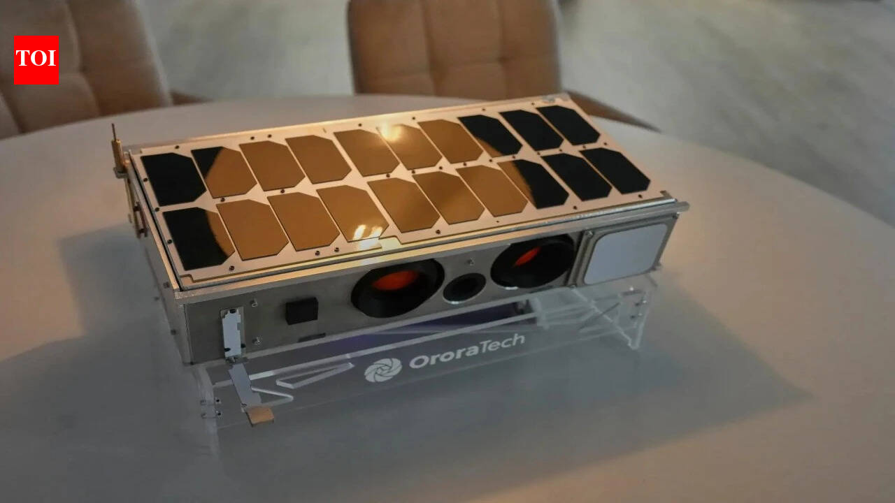
Greece has integrated a dedicated constellation of four small, AI-enabled satellites into its national wildfire response system. According to the European Space Agency, the four 8U CubeSats were launched on 3 May 2026 aboard a SpaceX Falcon 9 CAS500-2 mission and form the first national satellite capability devoted to wildfire detection and tracking. The satellites were developed by German firm OroraTech under Greece's National Small Satellite Programme, with programme support and technical backing from the European Space Agency and EU Recovery and Resilience Facility funding (ESA). The Associated Press reports the thermal sensors can flag fires as small as 4 meters, and that AI models are used to filter false positives and send alerts to incident commanders. Earlier coverage by The Next Web and OroraTech's product pages describe a broader goal of integrating satellite feeds, ground sensors, and analytics for national early warning and operational monitoring.
What happened
Greece has put a constellation of four small satellites into operational use for wildfire detection and tracking, according to the European Space Agency. Per ESA, the four 8U CubeSats were launched on 3 May 2026 aboard a SpaceX Falcon 9 CAS500-2 mission and constitute what ESA describes as a world first for a national satellite capability dedicated to wildfires. ESA states the satellites were developed under the Greek National Small Satellite Programme, funded in part through the EU Recovery and Resilience Facility, and overseen by the Hellenic Space Center and the Greek Ministry of Digital Governance and Artificial Intelligence.
Technical details
The satellites are based on an 8U CubeSat platform and carry thermal sensors for space-based thermal monitoring, per ESA. The Associated Press reports the thermal payloads can detect nascent blazes down to roughly 4 meters (13 feet) across and that on-orbit data undergoes AI processing to filter false positives such as hot roofs or sunlit rocks before alerts are delivered to firefighting commanders. OroraTech's public materials describe its Wildfire Solution as fusing imagery from the company's satellites with data from 35+ satellite and ground sources and applying detection and spread-prediction algorithms before delivering operational alerts.
Editorial analysis - technical context
Companies operating in space-based wildfire monitoring combine three technical elements: higher revisit cadence from small-satellite constellations, thermal-infrared sensors tuned for fire radiative power, and ML models trained to suppress false alarms and prioritise detections. Observed patterns in similar programmes show that improving temporal coverage (more frequent revisits) often yields earlier detection, while AI-driven false-alarm filtering is crucial to keep operational channels clear for incident commanders. Data fusion across multiple sensors and provenance metadata also reduces single-sensor failure modes and supports confidence scoring for alerts.
Context and significance
Industry context: National investment in sovereign Earth observation capability has accelerated across Europe, and ESA frames the Hellenic Fire System as an example of European cooperation converting innovation into operational capability. The Associated Press frames the Greek deployment as the first instance of a national firefighting system integrating a dedicated satellite array. Earlier reporting by The Next Web in 2024 noted a EUR 20 million contract award to OroraTech by Greece's Ministry of Digital Governance; OroraTech's public materials describe a longer-term ambition for a larger constellation. For practitioners, the operationalisation of AI-processed thermal detections at national scale is a useful case study in integrating remote-sensing pipelines into emergency workflows, including needs for low-latency processing, false-positive suppression, and clear alert prioritisation.
What to watch
Observers should follow:
- •operational metrics reported by Greek authorities or ESA such as median detection-to-alert latency and false-positive rate
- •reported scaling of the constellation and ground segment-ESA notes the national programme is planned to expand to 13 satellites organised into instrument groups
- •interoperability with other EO sources such as radar satellites that Greece previously launched with ICEYE, and with civil-protection dispatch systems. Industry context: Practitioners evaluating similar systems will monitor how AI models are validated in diverse geographies and seasons, how provenance and confidence metadata are communicated to field teams, and how data-fusion strategies handle simultaneous multi-fire events
Quotes and sourcing
Simonetta Cheli, director of ESA's Earth Observation Programmes, said, "The Hellenic Fire System is a powerful example of what can be achieved through collaboration," in ESA's May 2026 release. Fire Service Col. Zisoula Ntasiou told The Associated Press that prioritisation among multiple simultaneous fires depends on metrics such as fire radiative power. The Next Web reported in 2024 that Greece awarded OroraTech a EUR 20 million contract to build a satellite-based early warning system; OroraTech's website describes its Wildfire Solution and related analytics products.
Limitations in reporting
Sources provide technical and programme-level descriptions but do not publish full operational performance figures for detections, latency, or false-alarm rates. The Greek government has not published a comprehensive public dataset of system alerts and follow-up ground confirmations in the cited material.
Key Points
- 1Greece has operationalised a four-satellite, AI-enabled thermal constellation to feed national firefighting workflows, improving temporal coverage and early detection.
- 2AI-driven false-alarm filtering and multi-source fusion are central to turning thermal detections into actionable alerts for incident commanders.
- 3For practitioners, the case highlights integration challenges: latency, confidence scoring, provenance, and validation across seasons and terrains.
Scoring Rationale
Notable operational deployment of AI-enabled remote-sensing at national scale, with verified ESA, AP, and OroraTech sourcing. The system is the first national dedicated wildfire satellite constellation, making it a relevant case study for practitioners in EO/ML pipelines. Impact is meaningful for AI+infrastructure/disaster-response practitioners but not a frontier-model development.
Sources
Primary source and supporting public references used for this report.
View 4 more sources
- Hellenic Fire System satellites launched for Greece - ESAesa.int
- Suitcase-sized satellites are scanning for Greek wildfires in a global first - AP/ABC Newsabcnews.com
- Greece Launches World's First National Wildfire Satellite System | OroraTechororatech.com
- Greece taps AI-powered satellite tech to build wildfire defence systemthenextweb.com
Practice interview problems based on real data
1,625 SQL & Python problems across 15 industry datasets — the exact type of data you work with.
Try 250 free problems

