Case Studytesseraunetembeddingsearth observation
Tessera Enables Nano-UNet Mapping Solar Farms
7.2
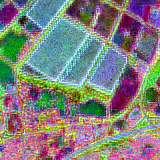
Researchers mapped UK solar farms from 2017–2024 using Tessera satellite embeddings and a nano-sized UNet with ~42,000 parameters, training on OpenStreetMap and the UK Renewable Energy Planning Database. Using a 25 km checkerboard spatial split (≈78%/11%/11%), the model reached 0.76 IoU, 0.80 precision and 0.93 recall, producing geojson outputs and region-level animations.
Key Points
- 1Trained a nano-UNet (≈42k parameters) on 128-d Tessera embeddings to segment solar farm pixels.
- 2Achieved 0.76 IoU with 0.80 precision and 0.93 recall, demonstrating strong detection performance.
- 3Enables fast, low-compute earth-observation workflows and scalable mapping using compact models.
Scoring Rationale
Practical, low-compute mapping approach with strong metrics and clear reproducibility; limited novelty and single-source validation constrain broader impact.
Sources
Public references used for this report.
Practice interview problems based on real data
1,625 SQL & Python problems across 15 industry datasets — the exact type of data you work with.
Try 250 free problems